
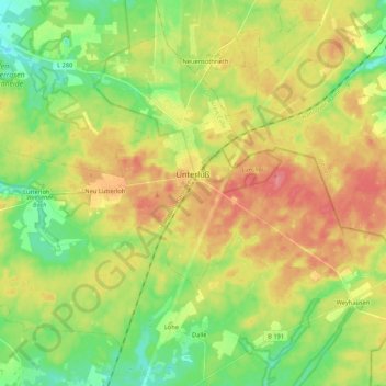
Unterlüß topographic map
Interactive map
Click on the map to display elevation.
About this map
Name: Unterlüß topographic map, elevation, terrain.
Average elevation: 325 ft
Minimum elevation: 217 ft
Maximum elevation: 449 ft
Other topographic maps
Click on a map to view its topography, its elevation and its terrain.
Hermannsburg
Deutschland > Niedersachsen > Landkreis Celle > Südheide
Hermannsburg, Südheide, Landkreis Celle, Niedersachsen, 29320, Deutschland
Average elevation: 233 ft
Baven
Deutschland > Niedersachsen > Landkreis Celle > Südheide
Baven, Südheide, Landkreis Celle, Niedersachsen, 29320, Deutschland
Average elevation: 213 ft
Lutterloh
Deutschland > Niedersachsen > Landkreis Celle > Südheide > Lutterloh
Lutterloh, Südheide, Landkreis Celle, Niedersachsen, Deutschland
Average elevation: 308 ft
Hof Severloh
Deutschland > Niedersachsen > Landkreis Celle > Südheide > Hermannsburg
Hof Severloh, Hermannsburg, Südheide, Landkreis Celle, Niedersachsen, Deutschland
Average elevation: 203 ft