
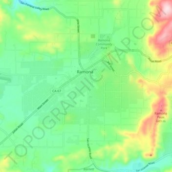
Ramona topographic map
Interactive map
Click on the map to display elevation.
About this map
Name: Ramona topographic map, elevation, terrain.
Average elevation: 1,529 ft
Minimum elevation: 1,171 ft
Maximum elevation: 2,300 ft
In January 2006, Ramona Valley was designated the country's 162nd American Viticultural Area (AVA) by the Alcohol and Tobacco Tax and Trade Bureau, which recognized the area for its distinctive microclimate, elevation, and soil attributes.
Other topographic maps
Click on a map to view its topography, its elevation and its terrain.
Ramona
United States > California > San Diego County > Ramona
Ramona, San Diego County, California, 92065, United States
Average elevation: 1,532 ft