
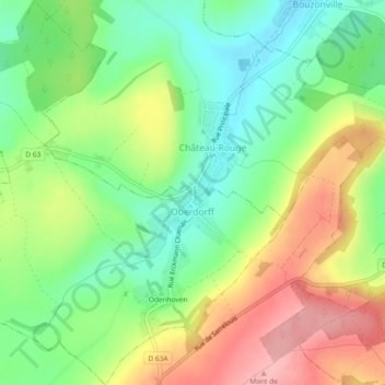
Oberdorff topographic map
Interactive map
Click on the map to display elevation.
About this map
Name: Oberdorff topographic map, elevation, terrain.
Average elevation: 1,014 ft
Minimum elevation: 820 ft
Maximum elevation: 1,270 ft
Other topographic maps
Click on a map to view its topography, its elevation and its terrain.
Rurange-lès-Thionville
Rurange-lès-Thionville, Thionville, Moselle, Grand Est, France métropolitaine, 57310, France
Average elevation: 643 ft
Réchicourt-le-Château
Réchicourt-le-Château, Sarrebourg-Château-Salins, Moselle, Grand Est, France métropolitaine, 57810, France
Average elevation: 915 ft
Hagondange
Hagondange, Metz, Moselle, Grand Est, France métropolitaine, 57300, France
Average elevation: 535 ft
Mondelange
Mondelange, Thionville, Moselle, Grand Est, France métropolitaine, 57300, France
Average elevation: 531 ft
Phalsbourg
Phalsbourg, Sarrebourg-Château-Salins, Moselle, Grand Est, France métropolitaine, 57370, France
Average elevation: 1,014 ft
Vieux Prés
France > Grand Est > Moselle > Vannecourt
Vieux Prés, Vannecourt, Sarrebourg-Château-Salins, Moselle, Grand Est, France métropolitaine, 57340, France
Average elevation: 817 ft
Ritzing
France > Grand Est > Moselle > Manderen-Ritzing
Ritzing, Manderen-Ritzing, Thionville, Moselle, Grand Est, France métropolitaine, 57480, France
Average elevation: 1,138 ft
Saint-Georges
France > Grand Est > Moselle > Saint-Georges
Saint-Georges, Sarrebourg-Château-Salins, Moselle, Grand Est, France métropolitaine, 57830, France
Average elevation: 1,004 ft
Laneuveville-en-Saulnois
Laneuveville-en-Saulnois, Sarrebourg-Château-Salins, Moselle, Grand Est, France métropolitaine, 57590, France
Average elevation: 919 ft
Waltembourg
France > Grand Est > Moselle > Waltembourg
Waltembourg, Sarrebourg-Château-Salins, Moselle, Grand Est, France métropolitaine, 57370, France
Average elevation: 1,056 ft
Thionville
Thionville, Moselle, Grand Est, France métropolitaine, 57100, France
Average elevation: 623 ft