
Millau topographic map
Interactive map
Click on the map to display elevation.
About this map
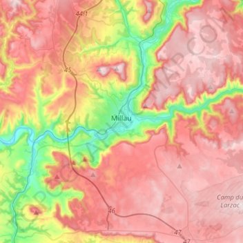
Name: Millau topographic map, elevation, terrain.
Location: Millau, Aveyron, Occitania, Metropolitan France, 12100, France (44.01667 2.99064 44.17985 3.24486)
Average elevation: 2,152 ft
Minimum elevation: 1,086 ft
Maximum elevation: 2,936 ft
The territory of this town lies across a southern portion of the Massif Central. It covers a large area of some 16,823 hectares (41,570 acres), which makes it the 25th largest metropolitan town in France. The municipality lies at the heart of the Grands Causses, a part of the Causse Rouge (east of the plateau Lévézou), and part of Larzac as well as part of the Black Causse. The city county seat is located in the lower part of the town, in a large depression at the confluence of the Tarn and Dourbie, at an altitude of about 340 m.
Other topographic maps
Click on a map to view its topography, its elevation and its terrain.
Villefranche-de-Rouergue
Villefranche-de-Rouergue, Aveyron, Occitania, Metropolitan France, 12200, France
Average elevation: 1,276 ft
Conques-en-Rouergue
Conques-en-Rouergue, Rodez, Aveyron, Occitania, Metropolitan France, 12320, France
Average elevation: 1,362 ft
Saint-Côme-d'Olt
Saint-Côme-d'Olt, Rodez, Aveyron, Occitania, Metropolitan France, 12500, France
Average elevation: 1,791 ft
Les Faisses
France > Occitania > Aveyron > Saint-Beauzély
Les Faisses, Saint-Beauzély, Millau, Aveyron, Occitania, Metropolitan France, 12620, France
Average elevation: 2,411 ft
Prades-d'Aubrac
Prades-d'Aubrac, Rodez, Aveyron, Occitania, Metropolitan France, 12470, France
Average elevation: 2,743 ft
Liaucous
France > Occitania > Aveyron > Mostuéjouls
Liaucous, Mostuéjouls, Millau, Aveyron, Occitania, Metropolitan France, 12720, France
Average elevation: 2,008 ft
Villevayre
France > Occitania > Aveyron > Najac
Villevayre, Najac, Villefranche-de-Rouergue, Aveyron, Occitania, Metropolitan France, 12270, France
Average elevation: 1,240 ft
Agen-d'Aveyron
Agen-d'Aveyron, Millau, Aveyron, Occitania, Metropolitan France, 12630, France
Average elevation: 2,205 ft
Livinhac-le-Haut
Livinhac-le-Haut, Villefranche-de-Rouergue, Aveyron, Occitania, Metropolitan France, 12300, France
Average elevation: 928 ft
Agnac
France > Occitania > Aveyron > Druelle Balsac
Agnac, Druelle Balsac, Rodez, Aveyron, Occitania, Metropolitan France, 12510, France
Average elevation: 1,906 ft
Saint-Chély-d'Aubrac
Saint-Chély-d'Aubrac, Rodez, Aveyron, Occitania, Metropolitan France, 12470, France
Average elevation: 3,251 ft
Saint-Beaulize
France > Occitania > Aveyron > Saint-Beaulize
Saint-Beaulize, Millau, Aveyron, Occitania, Metropolitan France, 12540, France
Average elevation: 2,280 ft
Palmas
France > Occitania > Aveyron > Palmas d'Aveyron
Palmas, Palmas d'Aveyron, Rodez, Aveyron, Occitania, Metropolitan France, 12310, France
Average elevation: 2,011 ft
La Bastide-Solages
La Bastide-Solages, Millau, Aveyron, Occitania, Metropolitan France, 12550, France
Average elevation: 1,273 ft