
Carmel Highlands topographic map
Interactive map
Click on the map to display elevation.
About this map
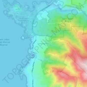
Name: Carmel Highlands topographic map, elevation, terrain.
Location: Carmel Highlands, Monterey County, California, 93923, USA (36.48413 -121.95162 36.52413 -121.91162)
Average elevation: 433 ft
Minimum elevation: -10 ft
Maximum elevation: 1,818 ft
Other topographic maps
Click on a map to view its topography, its elevation and its terrain.
Point Lobos Ranch
USA > California > Carmel Highlands
Point Lobos Ranch, Red Wolf Drive, Carmel Highlands, Monterey County, California, 93923, USA
Average elevation: 604 ft