
Sarti topographic map
Interactive map
Click on the map to display elevation.
About this map
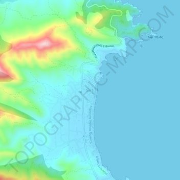
Name: Sarti topographic map, elevation, terrain.
Average elevation: 135 ft
Minimum elevation: -7 ft
Maximum elevation: 856 ft
Other topographic maps
Click on a map to view its topography, its elevation and its terrain.
Porto Koufo
Greece > Macedonia and Thrace > Chalkidiki Regional Unit > Toroni Municipal Unit > Porto Koufo
Porto Koufo, Toroni Municipal Unit, Municipality of Sithonia, Chalkidiki Regional Unit, Central Macedonia, Macedonia and Thrace, 630 72, Greece
Average elevation: 200 ft