
Danville topographic map
Interactive map
Click on the map to display elevation.
About this map
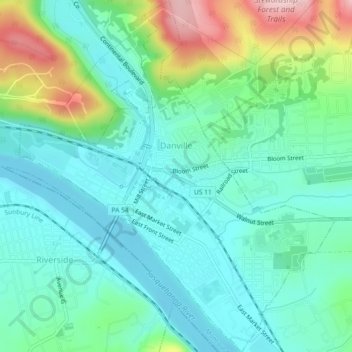
Name: Danville topographic map, elevation, terrain.
Location: Danville, Montour County, Pennsylvania, United States (40.94632 -76.63343 40.98065 -76.59256)
Average elevation: 600 ft
Minimum elevation: 417 ft
Maximum elevation: 1,115 ft
Other topographic maps
Click on a map to view its topography, its elevation and its terrain.
Exchange
United States > Pennsylvania > Montour County
Exchange, Montour County, Pennsylvania, 17772, United States
Average elevation: 643 ft
West Branch Chillisquaque Creek
United States > Pennsylvania > Montour County
West Branch Chillisquaque Creek, Montour County, Pennsylvania, 17884, United States
Average elevation: 551 ft
Oak Grove
United States > Pennsylvania > Montour County
Oak Grove, Montour County, Pennsylvania, United States
Average elevation: 636 ft