
El Khroub District topographic map
Interactive map
Click on the map to display elevation.
About this map
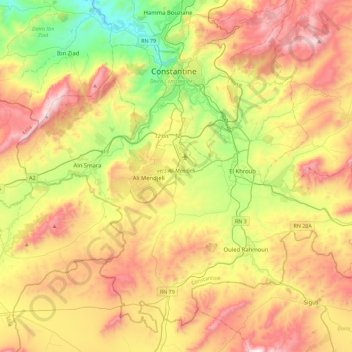
Name: El Khroub District topographic map, elevation, terrain.
Location: El Khroub District, Constantine, Algeria (36.09257 6.40589 36.41680 6.85954)
Average elevation: 2,539 ft
Minimum elevation: 991 ft
Maximum elevation: 4,393 ft
Other topographic maps
Click on a map to view its topography, its elevation and its terrain.
Hamma Bouziane
Algeria > Constantine > Hamma Bouziane District
Hamma Bouziane, Hamma Bouziane District, Constantine, Algeria
Average elevation: 1,877 ft
El Khroub
Algeria > Constantine > El Khroub District
El Khroub, El Khroub District, Constantine, Algeria
Average elevation: 2,523 ft
Belle Vue
Algeria > Constantine > Constantine > Belle Vue
Belle Vue, Constantine, Constantine District, Constantine, 25017, Algeria
Average elevation: 1,785 ft
Constantine
Algeria > Constantine > Constantine District
Constantine, Constantine District, Constantine, Algeria
Average elevation: 2,152 ft
Constantine
Algeria > Constantine > Constantine
Constantine, Constantine District, Constantine, 25000, Algeria
Average elevation: 2,215 ft
Ali Mendjeli
Algeria > Constantine > El Khroub District
Ali Mendjeli, El Khroub, El Khroub District, Constantine, 25005, Algeria
Average elevation: 2,451 ft