
Navajo Dam topographic map
Interactive map
Click on the map to display elevation.
About this map
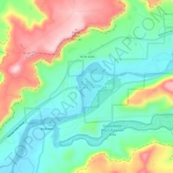
Name: Navajo Dam topographic map, elevation, terrain.
Location: Navajo Dam, San Juan County, New Mexico, United States (36.78490 -107.71778 36.82490 -107.67778)
Average elevation: 5,948 ft
Minimum elevation: 5,646 ft
Maximum elevation: 6,476 ft
Other topographic maps
Click on a map to view its topography, its elevation and its terrain.
Navajo Lake State Park
United States > New Mexico > San Juan County > Navajo Dam
Navajo Lake State Park, Navajo Dam, San Juan County, New Mexico, United States
Average elevation: 6,450 ft