
Ball Ground topographic map
Interactive map
Click on the map to display elevation.
About this map
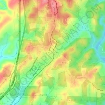
Name: Ball Ground topographic map, elevation, terrain.
Location: Ball Ground, Cherokee County, Georgia, 30107, United States (34.31823 -84.39657 34.35823 -84.35657)
Average elevation: 1,089 ft
Minimum elevation: 922 ft
Maximum elevation: 1,257 ft
According to the United States Census Bureau, the city has a total area of 5.8 square miles (15.1 km2), of which 0.031 square miles (0.08 km2), or 0.50%, is water. The city's elevation averages around 1,100 feet (340 m) above sea level, ranging from just over 1,000 feet (300 m) in the valleys to around 1,200 feet (370 m) on several hilltops within the city.