
Mattishall topographic map
Interactive map
Click on the map to display elevation.
About this map
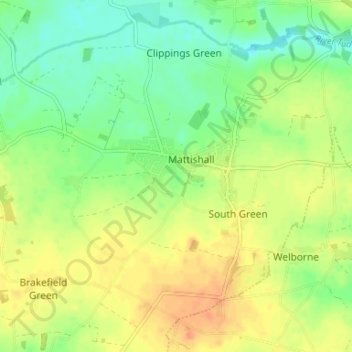
Name: Mattishall topographic map, elevation, terrain.
Location: Mattishall, Breckland District, Norfolk, England, United Kingdom (52.63973 0.99284 52.67570 1.05890)
Average elevation: 157 ft
Minimum elevation: 95 ft
Maximum elevation: 220 ft
Other topographic maps
Click on a map to view its topography, its elevation and its terrain.
Dereham
United Kingdom > England > Norfolk > Breckland District
Dereham, Breckland District, Norfolk, England, United Kingdom
Average elevation: 171 ft
Thetford
United Kingdom > England > Norfolk > Breckland District
Thetford, Breckland District, Norfolk, England, United Kingdom
Average elevation: 105 ft
Watton
United Kingdom > England > Norfolk > Breckland District
Watton, Breckland District, Norfolk, England, United Kingdom
Average elevation: 157 ft