
Rio Ponsul topographic map
Interactive map
Click on the map to display elevation.
About this map
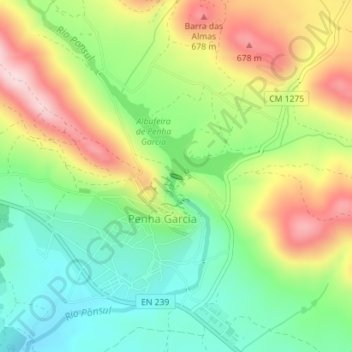
Name: Rio Ponsul topographic map, elevation, terrain.
Average elevation: 1,759 ft
Minimum elevation: 1,381 ft
Maximum elevation: 2,280 ft
Other topographic maps
Click on a map to view its topography, its elevation and its terrain.
Rio Ponsul
Portugal > Centro > Penha Garcia
Rio Ponsul, Penha Garcia, Idanha-a-Nova, Castelo Branco, Beira Interior Sul, Centro, Portugal
Average elevation: 1,864 ft