
Becerreá topographic map
Interactive map
Click on the map to display elevation.
About this map
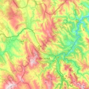
Name: Becerreá topographic map, elevation, terrain.
Location: Becerreá, Ancares, Lugo, Galicia, España (42.78785 -7.23071 42.98039 -7.05543)
Average elevation: 2,313 ft
Minimum elevation: 1,056 ft
Maximum elevation: 3,927 ft
Other topographic maps
Click on a map to view its topography, its elevation and its terrain.
Casa Fonchave
España > Galicia > Ancares > Becerreá > Casa Fonchave
Casa Fonchave, Fontarón, Becerreá, Ancares, Lugo, Galicia, 27698, España
Average elevation: 2,562 ft