
Kuwait City topographic map
Interactive map
Click on the map to display elevation.
About this map
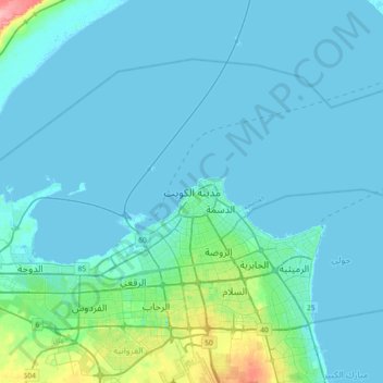
Name: Kuwait City topographic map, elevation, terrain.
Location: Kuwait City, Al Asimah, 15005, Kuwait (29.21965 47.81342 29.53965 48.13342)
Average elevation: 33 ft
Minimum elevation: -10 ft
Maximum elevation: 322 ft
Other topographic maps
Click on a map to view its topography, its elevation and its terrain.
Failaka
Kuwait > Al Asimah > Kuwait City
Failaka, Kuwait City, Al Asimah, Kuwait
Average elevation: 13 ft