
Seck topographic map
Interactive map
Click on the map to display elevation.
About this map
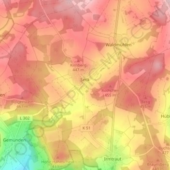
Name: Seck topographic map, elevation, terrain.
Location: Seck, Rennerod, Westerwaldkreis, Rhineland-Palatinate, Germany (50.55169 8.01489 50.59848 8.05913)
Average elevation: 1,365 ft
Minimum elevation: 879 ft
Maximum elevation: 1,624 ft
Other topographic maps
Click on a map to view its topography, its elevation and its terrain.
Holzbachschlucht
Germany > Rhineland-Palatinate > Westerwaldkreis > Seck
Holzbachschlucht, Dappricher Hof, Seck, Rennerod, Westerwaldkreis, Rhineland-Palatinate, 56479, Germany
Average elevation: 1,260 ft