
Schofield Barracks topographic map
Interactive map
Click on the map to display elevation.
About this map
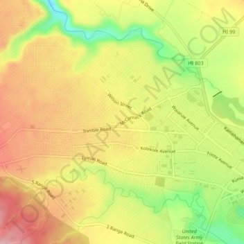
Name: Schofield Barracks topographic map, elevation, terrain.
Location: Schofield Barracks, Honolulu County, Hawaii, United States (21.47856 -158.08254 21.50819 -158.04103)
Average elevation: 915 ft
Minimum elevation: 597 ft
Maximum elevation: 1,158 ft
Schofield Barracks has a tropical savanna climate. Owing to a higher elevation, Schofield is slightly cooler year round than Honolulu, but is still well within the realms of a tropical climate. Precipitation patterns closely resemble those of mediterranean climates being found in mainland California, but its warm winters prevents the climate from being classified as such.
Other topographic maps
Click on a map to view its topography, its elevation and its terrain.
Waipio Acres
United States > Hawaii > Honolulu County > Mililani
Waipio Acres, Mililani, Honolulu County, Hawaii, United States
Average elevation: 755 ft
Mililani Mauka
United States > Hawaii > Honolulu County > Mililani
Mililani Mauka, Mililani, Honolulu County, Hawaii, United States
Average elevation: 833 ft
Oʻahu Forest National Wildlife Refuge
United States > Hawaii > Honolulu County > Mililani
Oʻahu Forest National Wildlife Refuge, Mililani, Honolulu County, Hawaii, United States
Average elevation: 1,496 ft