
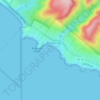
Emerald Bay topographic map
Interactive map
Click on the map to display elevation.
About this map
Name: Emerald Bay topographic map, elevation, terrain.
Average elevation: 121 ft
Minimum elevation: -3 ft
Maximum elevation: 719 ft
Other topographic maps
Click on a map to view its topography, its elevation and its terrain.
Top of the World
United States > California > Orange County > Laguna Beach
Top of the World, Laguna Beach, Orange County, California, 92651, United States
Average elevation: 436 ft
South Laguna
United States > California > Orange County > Laguna Beach
South Laguna, Laguna Beach, Orange County, CAL Fire Southern Region, California, 92607, United States
Average elevation: 210 ft
Three Arch Bay
United States > California > Orange County > Laguna Beach
Three Arch Bay, Laguna Beach, Orange County, CAL Fire Southern Region, California, 92629, United States
Average elevation: 187 ft