
Seven Oaks topographic map
Interactive map
Click on the map to display elevation.
About this map
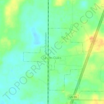
Name: Seven Oaks topographic map, elevation, terrain.
Location: Seven Oaks, Polk County, Texas, United States (30.84052 -94.87644 30.86696 -94.84295)
Average elevation: 223 ft
Minimum elevation: 184 ft
Maximum elevation: 282 ft
Other topographic maps
Click on a map to view its topography, its elevation and its terrain.
Livingston
United States > Texas > Polk County
Livingston, Polk County, Texas, United States
Average elevation: 207 ft
Lake Livingston State Park
United States > Texas > Polk County
Lake Livingston State Park, Polk County, Texas, United States
Average elevation: 141 ft
Lake Livingston
United States > Texas > Polk County
Lake Livingston, Polk County, Texas, United States
Average elevation: 217 ft
Segno
United States > Texas > Polk County
Segno, Polk County, Texas, United States
Average elevation: 197 ft
West Livingston
United States > Texas > Polk County
West Livingston, Polk County, Texas, 77351, United States
Average elevation: 138 ft
Corrigan
United States > Texas > Polk County
Corrigan, Polk County, Texas, 75939, United States
Average elevation: 249 ft
Tobacco Patch
United States > Texas > Polk County > Tobacco Patch
Tobacco Patch, Polk County, Texas, United States
Average elevation: 141 ft
Asia
United States > Texas > Polk County > Asia
Asia, Polk County, Texas, 75939, United States
Average elevation: 262 ft
Dallardsville
United States > Texas > Polk County > Dallardsville
Dallardsville, Polk County, Texas, 77332, United States
Average elevation: 249 ft
Goodrich
United States > Texas > Polk County
Goodrich, Polk County, Texas, United States
Average elevation: 125 ft
Onalaska
United States > Texas > Polk County
Onalaska, Polk County, Texas, 77360, United States
Average elevation: 161 ft
Blanchard
United States > Texas > Polk County
Blanchard, Polk County, Texas, United States
Average elevation: 154 ft