
Yinchuan City topographic map
Interactive map
Click on the map to display elevation.
About this map
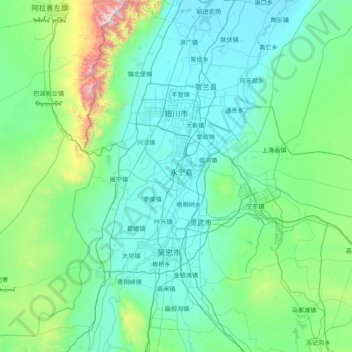
Name: Yinchuan City topographic map, elevation, terrain.
Location: Yinchuan City, Ningxia, China (37.64131 105.81492 38.87683 106.87776)
Average elevation: 4,396 ft
Minimum elevation: 3,596 ft
Maximum elevation: 11,421 ft
Yinchuan lies in the middle of the Yinchuan or Ningxia Plain. It is sheltered from the deserts of Mongolia by the high ranges of the Helan Mountains to its west. The Yellow River runs through Yinchuan from southwest to northeast. The average elevation of Yinchuan is 1,100 meters (about 3,608 feet). The urban center of Yinchuan lies about halfway between the Yellow River and the edge of Helan Mountains.
Other topographic maps
Click on a map to view its topography, its elevation and its terrain.
Yongning County
China > Ningxia > Yinchuan City
Yongning County, Yinchuan City, Ningxia, China
Average elevation: 4,012 ft
Guyuan
China > Ningxia > Guyuan > Guyan Subdistrict;古雁
Guyuan, Guyan Subdistrict;古雁, Yuanzhou District, Guyuan City, Ningxia, China
Average elevation: 6,152 ft