
Entracque topographic map
Interactive map
Click on the map to display elevation.
About this map
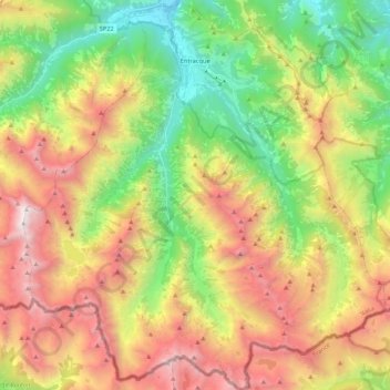
Name: Entracque topographic map, elevation, terrain.
Location: Entracque, Cuneo, Piedmont, Italy (44.11219 7.30526 44.26413 7.50380)
Average elevation: 6,155 ft
Minimum elevation: 2,566 ft
Maximum elevation: 10,745 ft
Other topographic maps
Click on a map to view its topography, its elevation and its terrain.
Bersia
Italy > Piedmont > Cuneo > San Damiano Macra
Bersia, San Damiano Macra, Cuneo, Piedmont, 12020, Italy
Average elevation: 4,383 ft
Fre
Italy > Piedmont > Cuneo > Montemale di Cuneo
Fre, Montemale di Cuneo, Cuneo, Piedmont, Italy
Average elevation: 3,271 ft
Giardino Famiglia Allemandi
Italy > Piedmont > Cuneo > Villar San Costanzo > Pramallé
Giardino Famiglia Allemandi, Pramallé, Villar San Costanzo, Cuneo, Piedmont, Italy
Average elevation: 2,146 ft
Punta Razil
Italy > Piedmont > Cuneo > Bagnolo Piemonte
Punta Razil, Bagnolo Piemonte, Cuneo, Piedmont, Italy
Average elevation: 6,588 ft
Pontechianale
Pontechianale, Cuneo, Piedmont, Italy
Average elevation: 8,028 ft
Limone Piemonte
Limone Piemonte, Cuneo, Piedmont, 12015, Italy
Average elevation: 5,312 ft