
Curicó topographic map
Interactive map
Click on the map to display elevation.
About this map
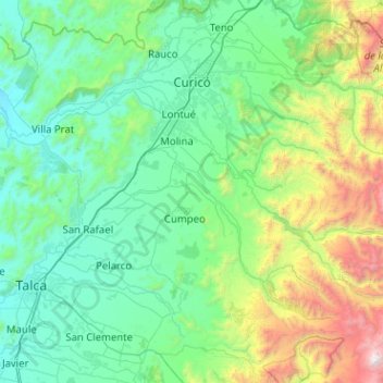
Name: Curicó topographic map, elevation, terrain.
Location: Curicó, Provincia de Curicó, Maule Region, Chile (-35.55953 -71.38359 -34.88813 -70.36789)
Average elevation: 2,159 ft
Minimum elevation: 128 ft
Maximum elevation: 12,867 ft
Other topographic maps
Click on a map to view its topography, its elevation and its terrain.
Guaico Tres
Chile > Maule Region > Provincia de Curicó > Romeral
Guaico Tres, Romeral, Provincia de Curicó, Maule Region, Chile
Average elevation: 1,473 ft
Molina
Chile > Maule Region > Provincia de Curicó
Molina, Provincia de Curicó, Maule Region, Chile
Average elevation: 2,195 ft
Vichuquén
Chile > Maule Region > Provincia de Curicó
Vichuquén, Provincia de Curicó, Maule Region, Chile
Average elevation: 427 ft