
La Châtre topographic map
Interactive map
Click on the map to display elevation.
About this map
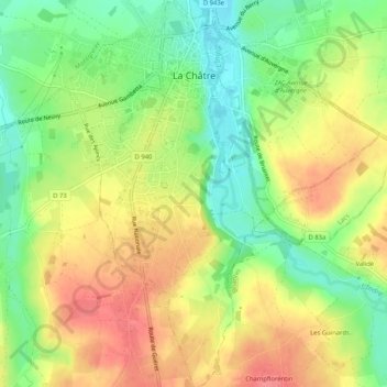
Name: La Châtre topographic map, elevation, terrain.
Average elevation: 774 ft
Minimum elevation: 653 ft
Maximum elevation: 896 ft
Other topographic maps
Click on a map to view its topography, its elevation and its terrain.
Villiers
France > Centre-Val de Loire > Indre
Villiers, Le Blanc, Indre, Centre-Val de Loire, Metropolitan France, 36290, France
Average elevation: 430 ft
Roy
France > Centre-Val de Loire > Indre > Sainte-Gemme
Roy, Sainte-Gemme, Le Blanc, Indre, Centre-Val de Loire, Metropolitan France, 36500, France
Average elevation: 341 ft
Lacs
France > Centre-Val de Loire > Indre
Lacs, La Châtre, Indre, Centre-Val de Loire, Metropolitan France, 36400, France
Average elevation: 735 ft
Dun-le-Poëlier
France > Centre-Val de Loire > Indre
Dun-le-Poëlier, Issoudun, Indre, Centre-Val de Loire, Metropolitan France, 36210, France
Average elevation: 367 ft
Chavin
France > Centre-Val de Loire > Indre > Chavin
Chavin, Châteauroux, Indre, Centre-Val de Loire, Metropolitan France, 36200, France
Average elevation: 755 ft
Châteauroux
France > Centre-Val de Loire > Indre > Châteauroux
Châteauroux, Indre, Centre-Val de Loire, Metropolitan France, 36000, France
Average elevation: 502 ft