
Ironton topographic map
Interactive map
Click on the map to display elevation.
About this map
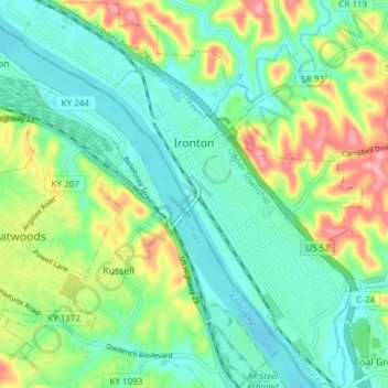
Name: Ironton topographic map, elevation, terrain.
Location: Ironton, Lawrence County, Ohio, United States (38.49940 -82.71649 38.55841 -82.65026)
Average elevation: 620 ft
Minimum elevation: 505 ft
Maximum elevation: 860 ft
Other topographic maps
Click on a map to view its topography, its elevation and its terrain.
South Point
United States > Ohio > Lawrence County
South Point, Lawrence County, Ohio, United States
Average elevation: 614 ft
Hamilton Township
United States > Ohio > Lawrence County
Hamilton Township, Lawrence County, Ohio, United States
Average elevation: 682 ft
Washington Township
United States > Ohio > Lawrence County
Washington Township, Lawrence County, Ohio, United States
Average elevation: 820 ft
Phillips Knob
United States > Ohio > Lawrence County
Phillips Knob, Decatur Township, Lawrence County, Ohio, United States
Average elevation: 869 ft
Perry Township
United States > Ohio > Lawrence County
Perry Township, Lawrence County, Ohio, United States
Average elevation: 719 ft
Elizabeth Township
United States > Ohio > Lawrence County
Elizabeth Township, Lawrence County, Ohio, 45659, United States
Average elevation: 758 ft
Lisman
United States > Ohio > Lawrence County > Lawrence > Lisman
Lisman, Lawrence, Elizabeth Township, Lawrence County, Ohio, 45659, United States
Average elevation: 715 ft
Windsor Township
United States > Ohio > Lawrence County
Windsor Township, Lawrence County, Ohio, United States
Average elevation: 741 ft