
Almendralejo topographic map
Interactive map
Click on the map to display elevation.
About this map
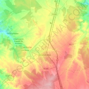
Name: Almendralejo topographic map, elevation, terrain.
Average elevation: 1,089 ft
Minimum elevation: 833 ft
Maximum elevation: 1,316 ft
Other topographic maps
Click on a map to view its topography, its elevation and its terrain.
Palomas
Spain > Extremadura > Tierra de Barros
Palomas, Tierra de Barros, Badajoz, Extremadura, Spain
Average elevation: 1,155 ft