
Irvine topographic map
Interactive map
Click on the map to display elevation.
About this map
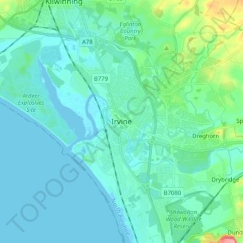
Name: Irvine topographic map, elevation, terrain.
Location: Irvine, North Ayrshire, Scotland, KA12 0AX, United Kingdom (55.57431 -4.70556 55.65431 -4.62556)
Average elevation: 43 ft
Minimum elevation: -7 ft
Maximum elevation: 285 ft
Other topographic maps
Click on a map to view its topography, its elevation and its terrain.
Kilbirnie
United Kingdom > Scotland > North Ayrshire
Kilbirnie, North Ayrshire, Scotland, KA25 7BY, United Kingdom
Average elevation: 397 ft
Grangehill
United Kingdom > Scotland > North Ayrshire > Beith
Grangehill, Beith, North Ayrshire, Scotland, KA15 2JJ, United Kingdom
Average elevation: 315 ft
Ballochmartin
United Kingdom > Scotland > North Ayrshire > Millport > Ballochmartin
Ballochmartin, Millport, North Ayrshire, Scotland, KA28 0HQ, United Kingdom
Average elevation: 72 ft
Kilwinning
United Kingdom > Scotland > North Ayrshire
Kilwinning, North Ayrshire, Scotland, KA13 6AD, United Kingdom
Average elevation: 118 ft