
Maria da Fé topographic map
Interactive map
Click on the map to display elevation.
About this map
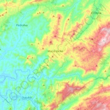
Name: Maria da Fé topographic map, elevation, terrain.
Average elevation: 3,835 ft
Minimum elevation: 2,720 ft
Maximum elevation: 6,519 ft
The city is located in the dominant mesothermic climates in the southeast and south of Brazil, associated with its altitude. The climate is tropical in terms of precipitation but the temperature is affected by elevation, which leads to classify Maria da Fé as a highland tropical climate, as well as Campos do Jordão (Köppen: Cwb). The average temperature is 17 °C (maximum average 23.3 °C and minimum average of 10.1 °C), with warm summers but not as hot as places in valleys in the interior of the country and the winters are colds to Brazil and Minas Gerais. The total precipitation is 1738 mm. Different from oceanic climates, being in the end of the tropics, there is a dry season defined in the winter, they are fences of 7 to 8 cold fronts, without the fronts due to the air dryness, there would be only 40% of the total precipitation for the season. It is the only city in the state where the average temperature rise trend per decade reaches 1 °C. Being in the Mantiqueira Mountains, frost is a common event in normal winter. It can go from 10 occasions in several years.