
Moody topographic map
Interactive map
Click on the map to display elevation.
About this map
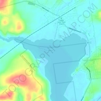
Name: Moody topographic map, elevation, terrain.
Location: Moody, Franklin County, New York, 12986, USA (44.20784 -74.50489 44.24784 -74.46489)
Average elevation: 1,591 ft
Minimum elevation: 1,532 ft
Maximum elevation: 1,791 ft
Other topographic maps
Click on a map to view its topography, its elevation and its terrain.
Simon Pond
Simon Pond, Lake Simon Road, Moody, Franklin County, New York, 12986, USA
Average elevation: 1,647 ft