
Long Bay Development topographic map
Interactive map
Click on the map to display elevation.
About this map
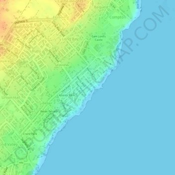
Name: Long Bay Development topographic map, elevation, terrain.
Location: Long Bay Development, Saint Philip, Barbados (13.11686 -59.43763 13.12429 -59.43105)
Average elevation: 36 ft
Minimum elevation: 0 ft
Maximum elevation: 121 ft
Other topographic maps
Click on a map to view its topography, its elevation and its terrain.
Indian Ground
Indian Ground, Saint Andrew, BB25012, Barbados
Average elevation: 522 ft
Mount Hillaby
Barbados > Saint Andrew > Hillaby
Mount Hillaby, Hillaby, Saint Andrew, BB22002, Barbados
Average elevation: 712 ft
Cliffs
Barbados > Saint John > Guinea
Cliffs, Guinea, Saint John, BB20024, Barbados
Average elevation: 561 ft
Ealing Park
Ealing Park, Christ Church, 17121, Barbados
Average elevation: 62 ft
Crane Beach
Crane Beach, cave path, Crane, Saint Philip, ST. PHILIP, Barbados
Average elevation: 36 ft