
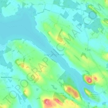
Lough Derravaragh topographic map
Interactive map
Click on the map to display elevation.
About this map
Name: Lough Derravaragh topographic map, elevation, terrain.
Average elevation: 279 ft
Minimum elevation: 180 ft
Maximum elevation: 676 ft
Other topographic maps
Click on a map to view its topography, its elevation and its terrain.
Lough Bane
Lough Bane, Crosskeys ED, The Municipal District of Kells, County Westmeath, County Meath, Leinster, Ireland
Average elevation: 427 ft
Rathwire
Rathwire, The Municipal District of Mullingar — Kinnegad, County Westmeath, Leinster, Ireland
Average elevation: 308 ft
Ardnurcher
Ardnurcher, Streamstown ED, The Municipal District of Athlone — Moate, County Westmeath, Leinster, Ireland
Average elevation: 233 ft
Athlone
Ireland > County Westmeath > Athlone
Athlone, The Municipal District of Athlone — Moate, County Westmeath, Leinster, N37 N1F2, Ireland
Average elevation: 144 ft
Fore
Fore, The Municipal District of Mullingar — Kinnegad, County Westmeath, Leinster, N91 TY06, Ireland
Average elevation: 361 ft
Lough Sewdy
Lough Sewdy, Ballymore ED, The Municipal District of Athlone — Moate, County Westmeath, Leinster, Ireland
Average elevation: 282 ft
Kilbixy
Kilbixy, Kilbixy ED, The Municipal District of Athlone — Moate, County Westmeath, Leinster, Ireland
Average elevation: 220 ft
Ballyloughloe
Ballyloughloe, The Municipal District of Athlone — Moate, County Westmeath, Leinster, N37 C4A0, Ireland
Average elevation: 236 ft
Athlone
Athlone, County Westmeath, Leinster, Ireland
Average elevation: 141 ft
Tyrrellspass
Tyrrellspass, The Municipal District of Athlone — Moate, County Westmeath, Leinster, Ireland
Average elevation: 328 ft
Dysart
Dysart, Bracklin ED, The Municipal District of Mullingar — Kinnegad, County Westmeath, Leinster, Ireland
Average elevation: 276 ft
Castletown Geoghegan
Castletown Geoghegan, Castletown ED, The Municipal District of Athlone — Moate, County Westmeath, Leinster, Ireland
Average elevation: 315 ft
Streamstown
Streamstown, The Municipal District of Athlone — Moate, County Westmeath, Leinster, Ireland
Average elevation: 344 ft
Glassan
Glassan, Glassan ED, The Municipal District of Athlone — Moate, County Westmeath, Leinster, Ireland
Average elevation: 187 ft
Lough Bane
Lough Bane, Knockarrow ED, The Municipal District of Mullingar — Kinnegad, County Westmeath, Leinster, Ireland
Average elevation: 217 ft
Rochfortbridge
Rochfortbridge, The Municipal District of Mullingar — Kinnegad, County Westmeath, Leinster, N91 AE6P, Ireland
Average elevation: 295 ft
Castletown
Castletown, The Municipal District of Mullingar — Kinnegad, County Westmeath, Leinster, A82 F8D2, Ireland
Average elevation: 289 ft
Moate
Moate, The Municipal District of Athlone — Moate, County Westmeath, Leinster, N37 WK44, Ireland
Average elevation: 249 ft
Toberclare
Toberclare, Auburn ED, The Municipal District of Athlone — Moate, County Westmeath, Leinster, Ireland
Average elevation: 203 ft
The Municipal District of Mullingar — Kinnegad
The Municipal District of Mullingar — Kinnegad, County Westmeath, Leinster, Ireland
Average elevation: 295 ft
Castlelost
Castlelost, Castlelost ED, The Municipal District of Mullingar — Kinnegad, County Westmeath, Leinster, Ireland
Average elevation: 305 ft
Banagher
Banagher, Huntingdon ED, The Municipal District of Mullingar — Kinnegad, County Westmeath, Leinster, Ireland
Average elevation: 315 ft
Garrycastle
Garrycastle, Athlone East Rural ED, The Municipal District of Athlone — Moate, County Westmeath, Leinster, N37 EE71, Ireland
Average elevation: 161 ft
Mullingar
Ireland > County Westmeath > Mullingar
Mullingar, The Municipal District of Mullingar — Kinnegad, County Westmeath, Leinster, N91 FY58, Ireland
Average elevation: 331 ft
Mullingar
Mullingar, The Municipal District of Mullingar — Kinnegad, County Westmeath, Leinster, Ireland
Average elevation: 325 ft
Adamstown
Adamstown, Churchtown ED, The Municipal District of Athlone — Moate, County Westmeath, Leinster, Ireland
Average elevation: 420 ft
Kiltotan and Collinstown
Kiltotan and Collinstown, Castlelost ED, The Municipal District of Mullingar — Kinnegad, County Westmeath, Leinster, Ireland
Average elevation: 318 ft
Lough Owel
Lough Owel, The Municipal District of Mullingar — Kinnegad, County Westmeath, Leinster, Ireland
Average elevation: 344 ft
Hill of Uisneach
Hill of Uisneach, R390, Ballymorin ED, The Municipal District of Athlone — Moate, County Westmeath, Leinster, Ireland
Average elevation: 420 ft
Kilbeggan
Kilbeggan, Kilbeggan ED, The Municipal District of Athlone — Moate, County Westmeath, Leinster, Ireland
Average elevation: 233 ft
Ballynaskeagh
Ballynaskeagh, Clonarney ED, The Municipal District of Mullingar — Kinnegad, County Westmeath, Leinster, Ireland
Average elevation: 295 ft
Clonmore
Clonmore, Castledaly ED, The Municipal District of Athlone — Moate, County Westmeath, Leinster, Ireland
Average elevation: 177 ft
Balrath
Balrath, Churchtown ED, The Municipal District of Athlone — Moate, County Westmeath, Leinster, Ireland
Average elevation: 420 ft
Paslicktown
Paslicktown, Belvidere ED, The Municipal District of Mullingar — Kinnegad, County Westmeath, Leinster, Ireland
Average elevation: 341 ft
Ballykilroe
Ballykilroe, Ballynagore ED, The Municipal District of Athlone — Moate, County Westmeath, Leinster, Ireland
Average elevation: 292 ft
Griffinstown
Griffinstown, Griffinstown ED, The Municipal District of Mullingar — Kinnegad, County Westmeath, Leinster, Ireland
Average elevation: 272 ft
Ballinea
Ireland > County Westmeath > Ballinea
Ballinea, The Municipal District of Mullingar — Kinnegad, County Westmeath, Leinster, Ireland
Average elevation: 328 ft
Clonmoyle
Clonmoyle, Russellstown ED, The Municipal District of Mullingar — Kinnegad, County Westmeath, Leinster, Ireland
Average elevation: 354 ft
Simonstown
Ireland > County Westmeath > Simonstown
Simonstown, Coole ED, The Municipal District of Mullingar — Kinnegad, County Westmeath, Leinster, Ireland
Average elevation: 262 ft
Multyfarnham
Ireland > County Westmeath > Multyfarnham
Multyfarnham, The Municipal District of Mullingar — Kinnegad, County Westmeath, Leinster, N91 Y293, Ireland
Average elevation: 289 ft
Milltown
Milltown, Milltown ED, The Municipal District of Mullingar — Kinnegad, County Westmeath, Leinster, Ireland
Average elevation: 276 ft
Killucan
Ireland > County Westmeath > Killucan
Killucan, The Municipal District of Mullingar — Kinnegad, County Westmeath, Leinster, Ireland
Average elevation: 318 ft
The Municipal District of Athlone — Moate
The Municipal District of Athlone — Moate, County Westmeath, Leinster, Ireland
Average elevation: 226 ft
Kiltoom
Kiltoom, Coolure ED, The Municipal District of Mullingar — Kinnegad, County Westmeath, Leinster, Ireland
Average elevation: 262 ft
Muckanagh
Muckanagh, Muckanagh ED, The Municipal District of Athlone — Moate, County Westmeath, Leinster, Ireland
Average elevation: 125 ft
Kinnegad
Ireland > County Westmeath > Kinnegad
Kinnegad, Kinnegad ED, The Municipal District of Mullingar — Kinnegad, County Westmeath, Leinster, Ireland
Average elevation: 246 ft