
Saint Pierre and Miquelon topographic map
Interactive map
Click on the map to display elevation.
About this map
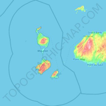
Name: Saint Pierre and Miquelon topographic map, elevation, terrain.
Location: Saint Pierre and Miquelon, France (46.55072 -56.69730 47.36500 -55.90333)
Average elevation: 26 ft
Minimum elevation: -3 ft
Maximum elevation: 817 ft
Other topographic maps
Click on a map to view its topography, its elevation and its terrain.
Saint Pierre and Miquelon
France > Saint Pierre and Miquelon
Saint Pierre and Miquelon, France
Average elevation: 36 ft
Miquelon
France > Saint Pierre and Miquelon > Miquelon
Miquelon, Saint Pierre and Miquelon, 97500, France
Average elevation: 20 ft
Dolisie
France > Saint Pierre and Miquelon > Miquelon-Langlade
Dolisie, Miquelon-Langlade, Saint Pierre and Miquelon, 97500, France
Average elevation: 344 ft