
Padua topographic map
Interactive map
Click on the map to display elevation.
About this map
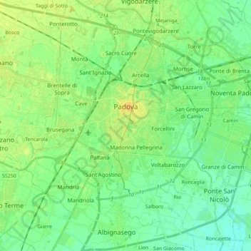
Name: Padua topographic map, elevation, terrain.
Location: Padua, Province of Padua, Veneto, 35121-35143, Italy (45.33957 11.80541 45.45737 11.97644)
Average elevation: 43 ft
Minimum elevation: 13 ft
Maximum elevation: 82 ft
Other topographic maps
Click on a map to view its topography, its elevation and its terrain.
Massanzago
Italy > Veneto > Province of Padua
Massanzago, Province of Padua, Veneto, 35010, Italy
Average elevation: 56 ft
Isoletta
Italy > Veneto > Province of Padua > Piove di Sacco > Corte
Isoletta, Corte, Piove di Sacco, Province of Padua, Veneto, Italy
Average elevation: 7 ft
Villatora
Italy > Veneto > Province of Padua
Villatora, Saonara, Province of Padua, Veneto, 35027, Italy
Average elevation: 33 ft
Battaglia Terme
Italy > Veneto > Province of Padua
Battaglia Terme, Province of Padua, Veneto, 35041, Italy
Average elevation: 69 ft