
Baker City topographic map
Interactive map
Click on the map to display elevation.
About this map
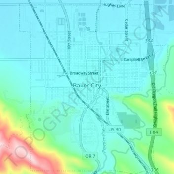
Name: Baker City topographic map, elevation, terrain.
Location: Baker City, Baker County, Oregon, 97814, United States (44.75151 -117.85939 44.79728 -117.80405)
Average elevation: 3,556 ft
Minimum elevation: 3,386 ft
Maximum elevation: 4,472 ft
Other topographic maps
Click on a map to view its topography, its elevation and its terrain.
Haines
United States > Oregon > Baker County
Haines, Baker County, Oregon, United States
Average elevation: 3,337 ft
Halfway
United States > Oregon > Baker County
Halfway, Baker County, Oregon, 97834, United States
Average elevation: 2,671 ft
Greenhorn
United States > Oregon > Baker County
Greenhorn, Baker County, Oregon, United States
Average elevation: 6,194 ft
Durkee
United States > Oregon > Baker County
Durkee, Baker County, Oregon, 97905, United States
Average elevation: 2,759 ft
Rock Creek Butte
United States > Oregon > Baker County
Rock Creek Butte, Baker County, Oregon, United States
Average elevation: 7,707 ft
Huntington
United States > Oregon > Baker County
Huntington, Baker County, Oregon, 97907, United States
Average elevation: 2,346 ft
Sumpter
United States > Oregon > Baker County
Sumpter, Baker County, Oregon, 97877, United States
Average elevation: 4,570 ft