
Bray topographic map
Interactive map
Click on the map to display elevation.
About this map
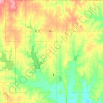
Name: Bray topographic map, elevation, terrain.
Location: Bray, Stephens County, Oklahoma, United States (34.53599 -97.89683 34.68162 -97.75622)
Average elevation: 1,207 ft
Minimum elevation: 1,040 ft
Maximum elevation: 1,421 ft
Other topographic maps
Click on a map to view its topography, its elevation and its terrain.
Velma
United States > Oklahoma > Stephens County
Velma, Stephens County, Oklahoma, 73491, United States
Average elevation: 1,050 ft
Comanche
United States > Oklahoma > Stephens County
Comanche, Stephens County, Oklahoma, 73529, United States
Average elevation: 1,033 ft
Loco
United States > Oklahoma > Stephens County
Loco, Stephens County, Oklahoma, United States
Average elevation: 945 ft
Countyline
United States > Oklahoma > Stephens County
Countyline, Stephens County, Oklahoma, 73425, United States
Average elevation: 1,017 ft
Marlow
United States > Oklahoma > Stephens County
Marlow, Stephens County, Oklahoma, 73055, United States
Average elevation: 1,263 ft
Duncan
United States > Oklahoma > Stephens County
Duncan, Stephens County, Oklahoma, 73533, United States
Average elevation: 1,148 ft