
Countyline topographic map
Interactive map
Click on the map to display elevation.
About this map
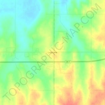
Name: Countyline topographic map, elevation, terrain.
Location: Countyline, Stephens County, Oklahoma, 73425, United States (34.42870 -97.58281 34.46870 -97.54281)
Average elevation: 1,017 ft
Minimum elevation: 935 ft
Maximum elevation: 1,109 ft
Other topographic maps
Click on a map to view its topography, its elevation and its terrain.
Bray
United States > Oklahoma > Stephens County
Bray, Stephens County, Oklahoma, United States
Average elevation: 1,207 ft
Velma
United States > Oklahoma > Stephens County
Velma, Stephens County, Oklahoma, 73491, United States
Average elevation: 1,050 ft
Comanche
United States > Oklahoma > Stephens County
Comanche, Stephens County, Oklahoma, 73529, United States
Average elevation: 1,033 ft
Loco
United States > Oklahoma > Stephens County
Loco, Stephens County, Oklahoma, United States
Average elevation: 945 ft
Marlow
United States > Oklahoma > Stephens County
Marlow, Stephens County, Oklahoma, 73055, United States
Average elevation: 1,263 ft
Duncan
United States > Oklahoma > Stephens County
Duncan, Stephens County, Oklahoma, 73533, United States
Average elevation: 1,148 ft