
Alpsray topographic map
Interactive map
Click on the map to display elevation.
About this map
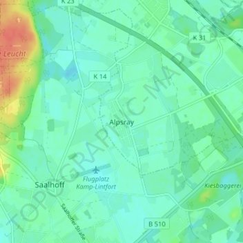
Name: Alpsray topographic map, elevation, terrain.
Average elevation: 92 ft
Minimum elevation: 56 ft
Maximum elevation: 190 ft
Other topographic maps
Click on a map to view its topography, its elevation and its terrain.
Millingen
Deutschland > Nordrhein-Westfalen > Kreis Wesel > Rheinberg > Millingen
Millingen, Rheinberg, Kreis Wesel, Nordrhein-Westfalen, 47495, Deutschland
Average elevation: 85 ft