
Ferch topographic map
Interactive map
Click on the map to display elevation.
About this map
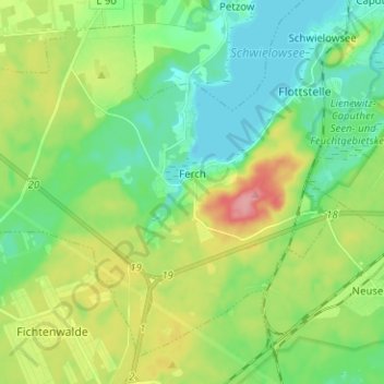
Name: Ferch topographic map, elevation, terrain.
Average elevation: 190 ft
Minimum elevation: 85 ft
Maximum elevation: 400 ft
Other topographic maps
Click on a map to view its topography, its elevation and its terrain.
Werder (Havel)
Allemagne > Brandebourg > Potsdam-Mittelmark
Werder (Havel), Potsdam-Mittelmark, Brandebourg, 14542, Allemagne
Average elevation: 141 ft