
Abbottabad topographic map
Interactive map
Click on the map to display elevation.
About this map
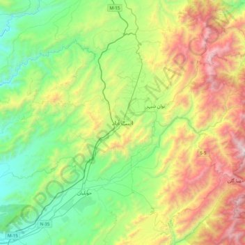
Name: Abbottabad topographic map, elevation, terrain.
Average elevation: 4,472 ft
Minimum elevation: 1,818 ft
Maximum elevation: 9,593 ft
Other topographic maps
Click on a map to view its topography, its elevation and its terrain.
Nathia Gali
Pakistan > Khyber Pakhtunkhwa > Abbottābād District
Nathia Gali, Abbottabad Tehsil, Abbottabad District, Hazara Division, Khyber Pakhtunkhwa, Pakistan
Average elevation: 7,011 ft