
Rochetaillée topographic map
Interactive map
Click on the map to display elevation.
About this map
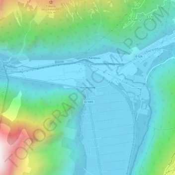
Name: Rochetaillée topographic map, elevation, terrain.
Average elevation: 3,386 ft
Minimum elevation: 2,306 ft
Maximum elevation: 7,677 ft
Other topographic maps
Click on a map to view its topography, its elevation and its terrain.
Lac Lauvitel
Frankrijk > Auvergne-Rhône-Alpes > Isère > Le Bourg-d'Oisans
Lac Lauvitel, Le Bourg-d'Oisans, Grenoble, Isère, Auvergne-Rhône-Alpes, Metropolitaans Frankrijk, 38520, Frankrijk
Average elevation: 6,266 ft