
Ban Hin Lat topographic map
Interactive map
Click on the map to display elevation.
About this map
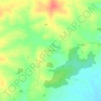
Name: Ban Hin Lat topographic map, elevation, terrain.
Location: Ban Hin Lat, Non Sa-at, Khon Kaen Province, 40210, Thailand (16.53662 102.33895 16.57662 102.37895)
Average elevation: 715 ft
Minimum elevation: 636 ft
Maximum elevation: 807 ft
Other topographic maps
Click on a map to view its topography, its elevation and its terrain.
Mancha Khiri
Thailand > Khon Kaen Province > Mancha Khiri
Mancha Khiri, Khon Kaen Province, Thailand
Average elevation: 554 ft
Nong Song Hong
Thailand > Khon Kaen Province > Nong Song Hong
Nong Song Hong, Khon Kaen Province, Thailand
Average elevation: 554 ft
Ban Si Thani
Thailand > Khon Kaen Province > Ban Si Thani
Ban Si Thani, Khon Kaen Province, 40000, Thailand
Average elevation: 525 ft
Khon Kaen Province
Khon Kaen Province, Thailand
Average elevation: 945 ft