
Municipio Roma VIII topographic map
Interactive map
Click on the map to display elevation.
About this map
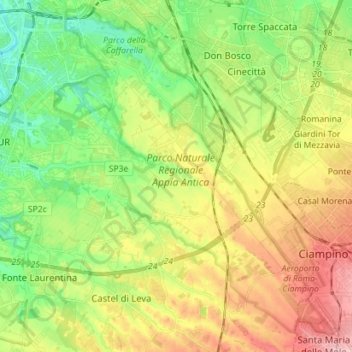
Name: Municipio Roma VIII topographic map, elevation, terrain.
Location: Municipio Roma VIII, Rome, RM, Lazio, Italy (41.77082 12.46054 41.87611 12.59600)
Average elevation: 226 ft
Minimum elevation: 7 ft
Maximum elevation: 531 ft
Other topographic maps
Click on a map to view its topography, its elevation and its terrain.
Municipio Roma I
Municipio Roma I, Rome, RM, Lazio, Italy
Average elevation: 167 ft