
日高郡 topographic map
Interactive map
Click on the map to display elevation.
About this map
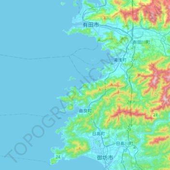
Name: 日高郡 topographic map, elevation, terrain.
Location: 由良町, 日高郡, Prefectura de Wakayama, 近畿地方, 649-1111, Japón (33.94437 134.88042 34.04617 135.17607)
Average elevation: 240 ft
Minimum elevation: -3 ft
Maximum elevation: 2,064 ft
Other topographic maps
Click on a map to view its topography, its elevation and its terrain.
琵琶湖
Japón > 近畿地方 > Higashiōmi
琵琶湖, 滋賀県道52号栗見八日市線, Higashiōmi, Prefectura de Shiga, 近畿地方, Japón
Average elevation: 883 ft