Geolocate

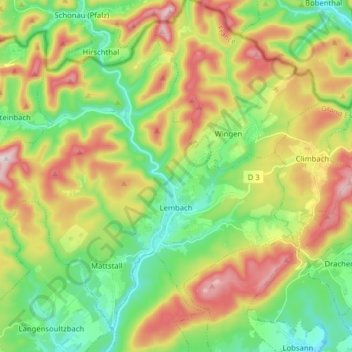
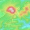
Lembach topographic map

Click on the map to display elevation.

Lembach

The commune, which covers an extensive land area, much of it uninhabitable owing to the topography, also includes the small village of Mattstall and the hamlet of Pfaffenbronn.

Wikipedia (CC-BY-SA 3.0)

About this map

Name: Lembach topographic map, elevation, terrain.

Location: Lembach, Haguenau-Wissembourg, Bas-Rhin, Grand Est, Metropolitan France, 67510, France (48.96777 7.68380 49.05757 7.84165)

Average elevation: 1,047 ft

Minimum elevation: 554 ft

Maximum elevation: 1,804 ft

Other topographic maps

Click on a map to view its topography, its elevation and its terrain.
Strasbourg

France > Grand Est > Bas-Rhin > Strasbourg

Average elevation: 505 ft

Ath

France > Grand Est > Bas-Rhin > Diemeringen

Average elevation: 837 ft

Taubensee

France > Grand Est > Bas-Rhin > Niederbronn-les-Bains

Average elevation: 1,299 ft

Le Haut des Monts

France > Grand Est > Bas-Rhin > Belmont

Average elevation: 2,785 ft

Le Climont

France > Grand Est > Bas-Rhin > Urbeis

Average elevation: 2,037 ft

Altenstadt

France > Grand Est > Bas-Rhin > Wissembourg

Average elevation: 564 ft

Gear up for your next adventure:

📦Gear Storage Bags - Organize and protect outdoor equipment
🎒Hydration Pack - Hands‑free water reservoir for long hikes
🧭Map Reading Tools - Tools and kits for map navigation
🏕️Tent Footprint - Protect your tent base from wear
👓Polarized Sunglasses - Outdoor sunglasses for glare reduction

As an Amazon Associate, this site earns from qualifying purchases at no extra cost to you.