
Tauramena topographic map
Interactive map
Click on the map to display elevation.
About this map
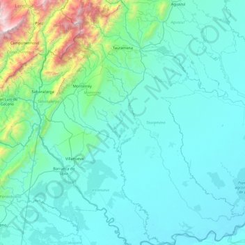
Name: Tauramena topographic map, elevation, terrain.
Location: Tauramena, Casanare, RAP Llanos, 854030, Colombia (4.30428 -72.91584 5.18472 -72.22972)
Average elevation: 1,371 ft
Minimum elevation: 486 ft
Maximum elevation: 8,888 ft
Other topographic maps
Click on a map to view its topography, its elevation and its terrain.
Santa Barabara
Santa Barabara, Trinidad, Casanare, Colombia
Average elevation: 466 ft
San Francisco
San Francisco, Recetor, Casanare, Colombia
Average elevation: 4,800 ft
Puerto Gaitan
Colombia > Casanare > Hato Corozal
Puerto Gaitan, Hato Corozal, Casanare, Colombia
Average elevation: 535 ft