
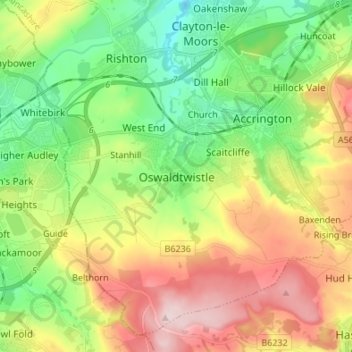
Oswaldtwistle topographic map
Interactive map
Click on the map to display elevation.
About this map
Name: Oswaldtwistle topographic map, elevation, terrain.
Average elevation: 663 ft
Minimum elevation: 269 ft
Maximum elevation: 1,237 ft
Other topographic maps
Click on a map to view its topography, its elevation and its terrain.
Accrington
United Kingdom > England > Lancashire > Hyndburn
Accrington, Hyndburn, Lancashire, England, BB5 1ES, United Kingdom
Average elevation: 653 ft
Clayton-le-Moors
United Kingdom > England > Lancashire > Hyndburn
Clayton-le-Moors, Hyndburn, Lancashire, England, BB5 5HW, United Kingdom
Average elevation: 492 ft
Great Harwood
United Kingdom > England > Lancashire > Hyndburn > Great Harwood
Great Harwood, Hyndburn, Lancashire, North West England, England, BB6 7NN, United Kingdom
Average elevation: 427 ft
Altham
United Kingdom > England > Lancashire > Hyndburn
Altham, Hyndburn, Lancashire, England, BB5 5UQ, United Kingdom
Average elevation: 348 ft
Rishton
United Kingdom > England > Lancashire > Hyndburn
Rishton, Hyndburn, Lancashire, England, BB1 4LE, United Kingdom
Average elevation: 492 ft