
Patel Nagar topographic map
Interactive map
Click on the map to display elevation.
About this map
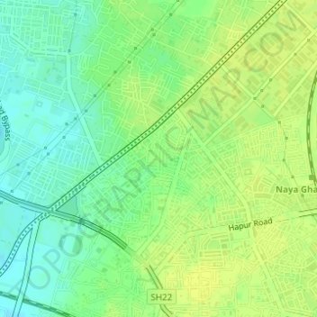
Name: Patel Nagar topographic map, elevation, terrain.
Location: Patel Nagar, Ghaziabad, Uttar Pradesh, 201001, India (28.66602 77.41291 28.68602 77.43291)
Average elevation: 696 ft
Minimum elevation: 663 ft
Maximum elevation: 715 ft
Other topographic maps
Click on a map to view its topography, its elevation and its terrain.
Indirapuram
India > Uttar Pradesh > Ghaziabad
Indirapuram, Ghaziabad, Uttar Pradesh, 201001, India
Average elevation: 669 ft
B Block Park Ramprastha Colony
India > Uttar Pradesh > Ghaziabad
B Block Park Ramprastha Colony, Chander Nagar, Kaushambi, Ghaziabad, Uttar Pradesh, 201001, India
Average elevation: 676 ft
Teacher Colony
India > Uttar Pradesh > Ghaziabad
Teacher Colony, Ghaziabad, Uttar Pradesh, 201001, India
Average elevation: 682 ft
JATWARA
India > Uttar Pradesh > Ghaziabad
JATWARA, Ghaziabad, Uttar Pradesh, 201001, India
Average elevation: 705 ft