
Town Centre topographic map
Interactive map
Click on the map to display elevation.
About this map
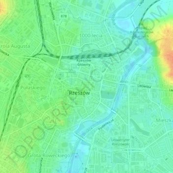
Name: Town Centre topographic map, elevation, terrain.
Location: Town Centre, Rzeszów, Subcarpathian Voivodeship, Poland (50.03046 21.99709 50.04634 22.02091)
Average elevation: 679 ft
Minimum elevation: 636 ft
Maximum elevation: 764 ft
Other topographic maps
Click on a map to view its topography, its elevation and its terrain.
Bulwar WSK Rzeszów
Poland > Subcarpathian Voivodeship > Rzeszów
Bulwar WSK Rzeszów, Dąbrowskiego, Rzeszów, Subcarpathian Voivodeship, Poland
Average elevation: 682 ft