Geolocate

Blumenau topographic map

Click on the map to display elevation.

About this map

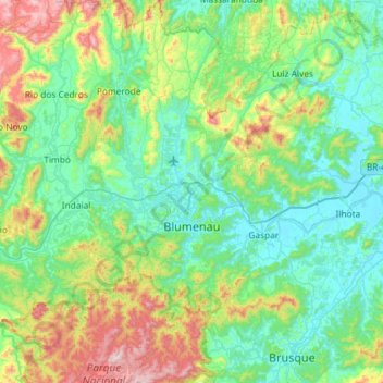
Name: Blumenau topographic map, elevation, terrain.

Location: Blumenau, Região Geográfica Imediata de Blumenau, Região Geográfica Intermediária de Blumenau, Santa Catarina, South Region, Brazil (-27.13200 -49.20072 -26.61280 -49.00966)

Average elevation: 722 ft

Minimum elevation: -7 ft

Maximum elevation: 3,251 ft

Other topographic maps

Click on a map to view its topography, its elevation and its terrain.

Rio Amazonas

Brazil > Santa Catarina > Joinville

Average elevation: 39 ft

Tubarão

Brazil > Santa Catarina > Tubarão

Average elevation: 318 ft

Linha Santa Lucia

Brazil > Santa Catarina > Modelo

Average elevation: 1,762 ft

Gear up for your next adventure:

🪶Survival Guide Book - Expert advice for emergency preparedness
🥇GPS Hiking Watch - Multi‑sport GPS watch with navigation and trail tracking
🩳Quick‑Dry Hiking Shorts - Comfortable and quick‑dry shorts for summer hiking
🥘Titanium Cookware - Durable, featherlight pots and pans for backpacking
🕶️Glacier Sunglasses - Side shields to protect eyes from high-altitude snow glare

As an Amazon Associate, this site earns from qualifying purchases at no extra cost to you.