
Sinaai topographic map
Interactive map
Click on the map to display elevation.
About this map
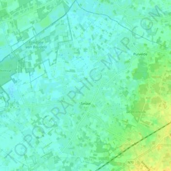
Name: Sinaai topographic map, elevation, terrain.
Location: Sinaai, Sint-Niklaas, East Flanders, 9112, Belgium (51.13416 3.98531 51.19160 4.06749)
Average elevation: 20 ft
Minimum elevation: 0 ft
Maximum elevation: 66 ft
Other topographic maps
Click on a map to view its topography, its elevation and its terrain.
Dekpriem
Belgium > East Flanders > Sint-Niklaas > Sint-Niklaas > Belsele
Dekpriem, Belsele, Sint-Niklaas, East Flanders, Flanders, 9111, Belgium
Average elevation: 59 ft