
Kirchlengern topographic map
Interactive map
Click on the map to display elevation.
About this map
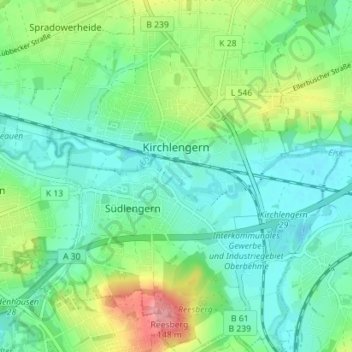
Name: Kirchlengern topographic map, elevation, terrain.
Location: Kirchlengern, Kreis Herford, North Rhine-Westphalia, Germany (52.17315 8.61800 52.21642 8.67751)
Average elevation: 262 ft
Minimum elevation: 167 ft
Maximum elevation: 499 ft
Other topographic maps
Click on a map to view its topography, its elevation and its terrain.
Herford
Germany > North Rhine-Westphalia > Kreis Herford
Herford, Kreis Herford, North Rhine-Westphalia, Germany
Average elevation: 351 ft
Spenge
Germany > North Rhine-Westphalia > Kreis Herford
Spenge, Kreis Herford, North Rhine-Westphalia, 32139, Germany
Average elevation: 344 ft
Ennigloh
Germany > North Rhine-Westphalia > Kreis Herford > Bünde > Gewinghausen
Ennigloh, Gewinghausen, Bünde, Kreis Herford, North Rhine-Westphalia, 32257, Germany
Average elevation: 253 ft
Herford
Germany > North Rhine-Westphalia > Kreis Herford
Herford, Kreis Herford, North Rhine-Westphalia, Germany
Average elevation: 299 ft