Geolocate

Scarista topographic map

Click on the map to display elevation.

About this map

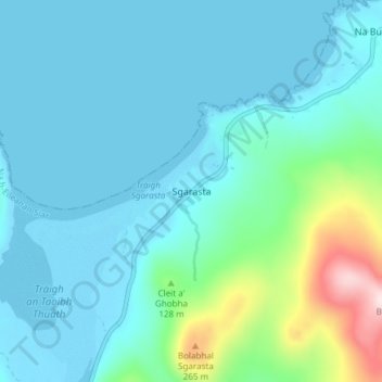
Name: Scarista topographic map, elevation, terrain.

Location: Scarista, Western Isles, Scotland, HS3 3HX, United Kingdom (57.80553 -7.06315 57.84553 -7.02315)

Average elevation: 197 ft

Minimum elevation: -3 ft

Maximum elevation: 1,273 ft

Other topographic maps

Click on a map to view its topography, its elevation and its terrain.

Àird

United Kingdom > Scotland > Western Isles

There is a dense cluster of lochs across almost the entire island, and almost all of the island is below 20 metres (70 feet) in elevation.

Average elevation: 16 ft

Vatersay

United Kingdom > Scotland > Western Isles > Vatersay

Average elevation: 62 ft

Gear up for your next adventure:

👖Convertible Hiking Pants - Versatile zip-off pants for changing altitudes and temperatures
🪶Camping Sleeping Pad - Comfortable sleeping pad for backpacking
🦶Carbon Trekking Poles - Reduce knee impact on steep descents with ultra-light poles
🧣Merino Neck Gaiters - Multi-functional headwear for wind and sun protection
🕶️Glacier Sunglasses - Side shields to protect eyes from high-altitude snow glare

As an Amazon Associate, this site earns from qualifying purchases at no extra cost to you.